
Dhu Heartach Lighthouse: A Scottish Lighthouse by The Stevensons
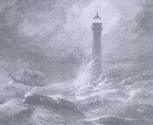
The tiny islet which is the Dhu Heartach (also spelled Dubh Artach, pronounced "Doo Artacc") lies 15 miles southwest from the Isle of Mull, Scotland and is the furthest outcropping of a reef known as the Torren Rocks. Over the years, most mariners, knowing the danger of the Torren Reef and giving it a wide berth, found themselves snared by Dhu Heartach. A desolate group of rocks, Dhu Heartach lies 20 miles southeast of a similar rock called Skerryvore. The Dhu Heartach consists of the main rock, five detached tide-covered hummocks, and two small sunken rocks.
The Inspector

In 1852, when the Lighthouse Board was established, a naval officer was placed in charge of each lighthouse district. He was assisted by an Army Corps of Engineer officer. In 1910 the Bureau of Lighthouses replaced the Lighthouse Board. In 1912 the Bureau replaced the military officers with civilians, except for the three Western River districts which remained under the charge of an Army Corps of Engineer officer until 1933. In that year they were combined into one district and placed under the control of a civilian.
- Read more about The Inspector
- Log in to post comments
A Lighthouse for Brandywine Shoal: America's First Screw-pile

Since the Colonial period, one of the major waterways on the eastern seaboard has been the Delaware Bay and River. The Bay and River, separating New Jersey from Pennsylvania and Delaware, stretches from the mouth all the way to Philadelphia, Camden and Trenton. Prior to the completion of the Ene Canal in 1825, which elevated New York City to a major port, Philadelphia and Boston were the primary seaports of the colonies and our new nation. One of the twelve colonial lighthouses was situated at Cape Henlopen, on the south side of the entrance to the Bay.
Matinicus Rock

The year is 1826, the new country is just fifty years old. The nation's coastline bustles with commerce. The young government, responding to the needs of industry, attempts to make the shipping lanes as safe as possible and acquires title to a lonely rock in the Atlantic off Maine's coast. Matinicus Rock is a barren outcropping off the coast of Maine. It is the southernmost feature of the Matinicus archipelago of five islands (four are partially wooded) and numerous high barren rocks.
- Read more about Matinicus Rock
- Log in to post comments
A Lighthouse for Race Rock

Thousands of years ago Long Island Sound was a large oval lake, carved out by the last Ice Age. At some point in time, the easternmost wall of this large lake eroded or otherwise collapsed, allowing the ocean to ebb and flow throughout the sound. The wall from Long Island to Connecticut, running northeast, consists of Plum, Little Gull and Fisher Islands as well as Valient Rock and Race Rock reefs. The remainder of this "wall" is below water, mostly 40 to 83 feet below low water.
- Read more about A Lighthouse for Race Rock
- Log in to post comments
Cape Hatteras!
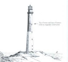
A long and very thin strip of land stretches south 175 miles along North Carolina's eastern shore. This barrier island, which is actually a series of islands, is known as the Outer Banks. These barrier islands migrate, constantly changing shape as they are affected by storms, ocean currents and even wind. During heavy winter storms the area can erode, only to accrete during the summer months. The Outer Banks is separated from the mainland by broad, shallow sounds and are occasionally breached by narrow inlets which open and close due to storms.
- Read more about Cape Hatteras!
- Log in to post comments
The Bishop: The Story Of The Bishop Rock Lighthouse
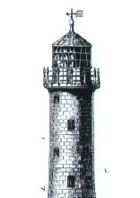
The Scilly Isles, of England, is the first landfall a mariner encounters when approaching the English Channel from the west. It was among these low lying, wave-washed islets that the Royal Navy experienced its worst peacetime disaster. In October of 1707 a naval squadron, commanded by Admiral Sir Cloudsley Shovel, was returning from the Mediterranean. The squadron encountered a gate shortly before making landfall and all but two of the frigates were swept onto the ledges and reefs which litter the western seaboard of the Scilly Isles.
Point Bonita Light Station

The discovery of gold at Sutter's Mill in 1848 changed San Francisco from a sleepy village to a boomtown, seemingly overnight. The thousands of ships bringing Easterners to the gold fields caused San Francisco Bay to become a forest of masts as crews abandoned their ships for the promise of fortune in the Sierras.
- Read more about Point Bonita Light Station
- Log in to post comments
The Building of the Detroit River Light Station
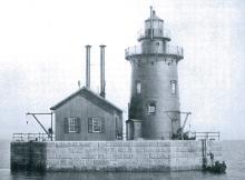
The vast majority of Great Lakes water borne commerce passes through the Detroit River. There was no busier shipping period than the last quarter of the 19th century. Vessels heading west from Buffalo navigated across shallow Lake Erie and then swung north into the very narrow Detroit River. The Detroit River is a swift running river that empties into the northwestern comer of Lake Erie dumping alluvial deposits that form narrow, shifting channels.
New London Lighthouse: America's Fourth Light Station

The New London Harbor Lighthouse was the fourth constructed in the colonies. Boston, established in 1716, was the first; Brant Point, erected in 1746 on Nantucket Island, was the second, and Beavertail, constructed in 1749, was third. The present New London Harbor Tower was constructed in 1800. For many years the mouth of the Thames River in Connecticut was one of the best natural harbors on the New England Coast. It is not surprising that a town named New London was established at the mouth of the river at an early date.