
Private Aids to Navigation

It's probably a surprise to members, but there are far more private aids to navigation in U.S. waters than government aids. Today, the Coast Guard maintains about 35,000 aids to navigation. They include lights, sound (fog) signals, daymarks, LORAN and OMEGA (electronic) stations and lighted and unlighted buoys. At the same time there are approximately 50,000 private aids to navigation.
- Read more about Private Aids to Navigation
- Log in to post comments
The Keeper's Pay

Our first lighthouse keeper, George Worthylake, was paid £50 a year. He was appointed keeper of the Boston Lighthouse on Little Brewster Island in 1716 by order of the general court of the Province of Massachusetts Bay. Adjusting for inflation and converting British pounds into American dollars, the 50£ is worth about $7,732 today. Of course, he had the use of a dwelling and government land and his expenses were few, no automobile to buy and maintain, no telephone, electricity, etc.
- Read more about The Keeper's Pay
- Log in to post comments
St. George Reef Lighthouse: A Nineteenth Century Engineering Feat
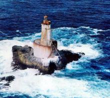
St. George Reef is made up of a series of rocks, pinnacles, and small islets extending into the Pacific Ocean about eight miles from Point St. George in northern California near the Oregon Border. Some of the obstructions are submerged and some are above water, depending on the stage of the tide. The area has long been a critical turning point for vessels navigating along the West Coast. Coastal navigation continued to increase as the West Coast developed after the Gold Rush, which began in 1849. But lighthouse construction was halted during the Civil War.
Isle of Shoals

Isle of Shoals is a cluster of eight islets anchored six miles off the east coast straddling the New Hampshire-Maine border. Five of them: Duck, Appledore, Malaga, Haley's (originally called Smuttynose) and Cedar, belong to Maine. The rest: Star, White, and Londoner, belong to New Hampshire. Appledore (once called Hog Island) is by far the largest and White is the only one of the cluster with a lighthouse. Over the years it has been called the Isle of Shoals Lighthouse as well as the White Island Lighthouse.
- Read more about Isle of Shoals
- Log in to post comments
The Smalls
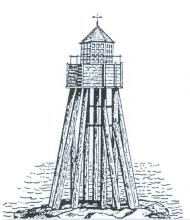
Extending out from the southwestern toe of Wales is a series of islets, reefs and rocks. Over the years, numerous vessels have fallen victim to these obstructions as they attempted to thread the relatively narrow St. George Channel between England and Ireland. The furthest west of these obstructions is cluster of rocks known as "The Smalls." This cluster of 20 rocks, some 20 miles from the nearest land, is constantly assaulted by wind and wave, and from every point of the compass. The highest rock of the Smalls rises only 12 feet above high water.
- Read more about The Smalls
- Log in to post comments
Cape Flattery Light Station

Cape Flattery is the most northwest point of the continental United States. It's a desolate and rigorous location and guards the southern entrance to the Strait of Juan de Fuca. Swirling, strong currents live here. The lofty mountains of Washington's Olympic Peninsula block storm clouds arriving from the northwest, causing the area to experience the heaviest rainfall in the country: 100 inches a year. The warm Japanese Current sweeps by Cape Flattery and the on-shore breezes create heavy walls of fog during much of the year.
- Read more about Cape Flattery Light Station
- Log in to post comments
Mount Desert Rock

Mount Desert Rock lies in the Atlantic Ocean, off Maine, some 22 miles from Mount Desert Island (both are pronounced "dessert"), and 26 miles from the mainland. The rock is a scant half-acre with the highest elevation being only 17 feet above high water. The station is assigned Light List number 1by the Coast Guard, the first light of our aids, which are numbered from north to south and east to west. It is also one of the most desolate stations ever conceived by our government.
- Read more about Mount Desert Rock
- Log in to post comments
Wolf Rock Lighthouse
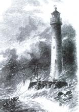
In 1855, after a three-year absence, James Douglass returned to Trinity House as the Chief Engineer. Trinity House is the corporation in charge of aids to navigation for England. During the next five years, he oversaw the construction of several lighthouses, many situated on shore, and one, The Smalls, a feat of some ingenuity. As it turned out, constructing The Smalls was good practice for what Trinity House handed him next. It was to be one of the most difficult and challenging that he or any other lighthouse builder was ever called on to undertake.
- Read more about Wolf Rock Lighthouse
- Log in to post comments
Fire Island Lighthouse
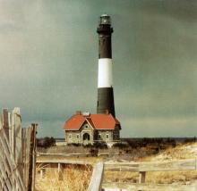
Fire Island is a unique barrier island with a varied ecosystem. The charms of the island are worth mentioning to set the stage for the story of the lighthouse. Lying off the southern coast of Long Island, Fire Island stretches 32 miles from Democrat Point at the west end to the Moriches Inlet on the east end. The Fire Island National Seashore manages the barrier beach plus a few small islands behind it and the boundary waters. This barrier island stands defiantly facing the Atlantic Ocean while protecting the waters of the Great South Bay, as well as the mainland of Long Island.
- Read more about Fire Island Lighthouse
- Log in to post comments
The Point Isabel Lighthouse
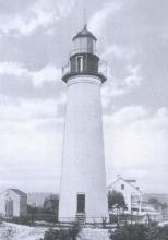
In the 1820s, American settlers streamed into the Mexican Territory of Texas in such numbers that Mexico became concerned, ceased giving land grants, and in 1830, banned further immigration. General Santa Anna established a dictatorship in 1834 and the following year the Americans in Texas revolted. The general and his army put down the revolt at the Battle of the Alamo in 1836, but Sam Houston countered with his rag-tag Texan army and defeated Santa Anna a month later, ensuring Texas's independence. For nine years Texas was an independent republic.
- Read more about The Point Isabel Lighthouse
- Log in to post comments