
Seguin Light Station, Maine
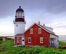
For more than two centuries, this lighthouse has been an important guide for mariners traveling along the Maine coast as well as for those entering the Kennebec River toward Bath and other ports. Even earlier, high Seguin Island, rising more than 100 feet above tihe sea, was a prominent landmark. In August 1607, the English founders of the Popham colony anchored at the island before landing on the mainland. When the explorer Samuel de Champlain sailed past the mouth of the Kennebec River in 1605, he aptly observed that the island looked like a giant tortoise.
- Read more about Seguin Light Station, Maine
- Log in to post comments
Eliphalet Grover at Boon Island, Maine, 1816-39

Boon Island Lighthouse, established in 1811 several miles off the coast of southern Maine, was one of the most isolated and desolate of New England's light stations. The first keeper was David Oliver, a carpenter who had helped build the station. Oliver soon resigned to serve as a mate on a Europe-bound ship. Thomas Hanna, a sea captain originally from Scotland and the grandfather of the Cape Elizabeth Lighthouse hero Marcus Hanna, succeeded Oliver. Hanna resigned May 1816.
Spring Point Ledge Light Station, Maine
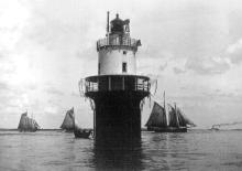
Spring Point Ledge is a dangerous obstruction on the west side of the main shipping channel from the south into Portland Harbor, just under two miles north-northwest of Portland Head. An 1896 newspaper article explained how the local fishermen found their way into the harbor while avoiding the ledge before the lighthouse was built. They would approach the tall, prominent Portland Observatory on the city's Munjoy Hill, and when it looked like Waterville Street ran right up to it, they knew they were in the right channel.
- Read more about Spring Point Ledge Light Station, Maine
- Log in to post comments
Cape Neddick Light Station, Maine

A short distance off the eastern point of Cape Neddick in the town of York, Maine, about two miles north of the entrance to them York River and a mile south of the entrance to the Cape Neddick River, is a high rocky island-about two and a half acres in area-known as the Nubble. It's separated from the area now known as Sohier Park on the mainland by a narrow channel, about 100 feet wide, that's almost dry at low tide. The explorer Bartholomew Gosnold, who met with local Indians there in May 1602, dubbed the island Savage Rock.
- Read more about Cape Neddick Light Station, Maine
- Log in to post comments
Burnt Island Light Station, Maine
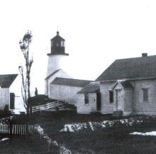
Since 1821, the Burnt Island Lighthouse has played a significant role in guiding vessels safely into one of Maine's best harbors. As described by the Secretary of Navy: "This is well known as one of the most important harbors upon the whole coast. It is easy of ingress and egress, large, safe in gales from any point ofthe compass, with good anchorage in any part of it. It is a harbor which all vessels bound east or west, when met by head winds or unfavorable weather, endeavor to make.
- Read more about Burnt Island Light Station, Maine
- Log in to post comments
Eagle Island Lighthouse

The Penobscot River originates deep in the forested wilderness of Maine and nearly splits the state in half. Early settlers found the river a ready-made highway to harvest the great wealth of timber in the region. In the period from 1832 to 1888, nearly 9 billion board feet went downriver to Bangor, making the city the "Lumber Port of the World" and later, the "Queen City." Nearly a hundred sawmills operating on the river cut the logs into standardized lengths which were then floated downriver to the falls where Bangor was built, then loaded aboard ships and sent around the world.
- Read more about Eagle Island Lighthouse
- Log in to post comments
Lighting a River: Maine's Kennebec River

In their 1892 Report to congress, the Lighthouse Board noted that: "There were 3,137 arrivals of vessels in this river during the year, not counting the steamers which ply daily. The steamers Kennebec, 1,652 tons, and Sagadahoc, 1,413 tons, made ninety-six round-trips each from Gardiner to Boston. Other passenger steamers ply on the river between Bath to Augusta, Boothbay and Popham Beach ... the number of passengers carried was 232,150 ... The vessels arriving will average 450 tons.
- Read more about Lighting a River: Maine's Kennebec River
- Log in to post comments
The Monhegan Island Lighthouse

Some ten miles off the Maine Coast is a small island, which has been an important natural landmark. Since times immemorial, the island has felt the tread of mankind. In aboriginal times, the Penobscot Indians rowed the long distance to the island to fish and process whales. In fact, the name of the island, Monhegan, derives from the Penobscot word meaning "Faraway Island." Due to its location, for years Monhegan Island has been the first landfall for mariners approaching the Maine Coast from sea.
- Read more about The Monhegan Island Lighthouse
- Log in to post comments
Cape Elizabeth and the Storm of 1947: Lighthouse Memories
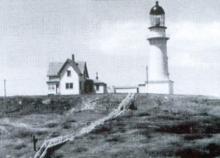
March 3, 1947 This is a day long to be remembered. The wind blew up to 80 miles per hour and it rained and sleeted all night. There was no electric power from 4 pm the day before until noon on this date. We had to keep the generator operating all the time after the tower optic was placed in operation. We used an Aladdin lamp until it went dry, then I found a lamp that had some oil in it.
Mainland Soil: Mount Desert Rock
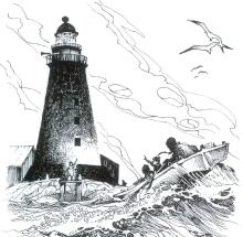
Amanda's fingers tightened on the railing of the windy lighthouse gallery. She shaded her eyes from the afternoon sun and scanned the gray horizon. A distant glimmer caught her attention, the sparkle of Isaac's shiny, brass oarlocks. The dory took shape and ponderously crept closer until Amanda could discern the wool-capped heads of her two sons and Isaac's arms moving rhythmically at the oars. Nearly two weeks had passed since Isaac left for the mainland to get supplies and have the boys fitted for new shoes.
- Read more about Mainland Soil: Mount Desert Rock
- Log in to post comments