
In the spring of 1853, Samuel Burgess was appointed keeper of Matinicus Rock Light Station. His family included an invalid wife, a son and four daughters. Within a few years the son left to become a fisherman and, in fact, Samuel also spent a great deal of time away from the light station fishing in Bay Chaleur. His only assistant was the eldest daughter, Abbie. She became quite proficient in the duties of lighthouse keeper. On January 19, 1856, when she was 17 years old and while her father was off the island, a winter gale lashed the islet.

Maintaining shore lights locations at strategic locations along the coastlines of the middle-Atlantic states has always been difficult. The Atlantic coast is in a constant state of flux. Inlets to protected interior waters possess a natural tendency to work south. Therefore the frequently perilous state of "Old Barney," as the Barnegat Lighthouse on Long Beach Island in New Jersey was nicknamed at some point in the dim past, cannot be separated from the natural antics of Bamegat Inlet. They may be compared to an incompatible married couple.

Since storms never cease driving ships on conveninet rocks, the need for at least a temporary light to mark the rocks of Cohasset was clearly indicated. Until a new, permanent tower could be constructed, the government stationed a lightship off Minots Ledge. When the storm of 1851 subsided, the steam tugboat R. B. Forbes was fitted with a temporary illuminant and anchored half a mile north of the Outer Minot in 15 fathoms of water [90 feet] to serve as a lightship. On April 20 another gale blew up of such intensity that the temporary lightship was forced to withdraw into Boston Harbor.

From 1927 until the early months of World War II, an ungainly buoy tender named ACACIA had maintained the lighthouses and buoys scattered about the waters surrounding Puerto Rico. Doggedly steaming back and forth across the Caribbean, ACACIA had carried out her unassuming but essential mission without incident, save for a couple of hurricanes. Her modest labors were abruptly ended, however, when in the pre-dawn hours of March 15, 1942, she happened across a German submarine.

Extending out from the southwestern toe of Wales is a series of islets, reefs and rocks. Over the years, numerous vessels have fallen victim to these obstructions as they attempted to thread the relatively narrow St. George Channel between England and Ireland. The furthest west of these obstructions is cluster of rocks known as "The Smalls." This cluster of 20 rocks, some 20 miles from the nearest land, is constantly assaulted by wind and wave, and from every point of the compass. The highest rock of the Smalls rises only 12 feet above high water.

Emily Fish and her niece Juliet, from all evidence in their backgrounds, were unlikely candidates to join the ranks of the women who tended the lights. Having the advantage of education and social position, why did they become involved in work so lonely and foreign to their backgrounds?

Visible for 15 miles across the Gulf of Mexico, the St. Marks Lighthouse is located at the mouth of the St. Marks River, in Wakulla County an area rich with history The lighthouse is located approximately 20 miles south of Florida's state capital, Tallahassee, and has been in operation since 1829. It is the second oldest lighthouse in Florida, and one of the most photographed landmarks on Florida's "Big Bend" coast. It is also a part of the St. Marks National Wildlife Refuge, established in 1931 which encompasses 68,000 acres and includes three counties.

The late morning sun was warm as the bus ambled across the moors of Galloway western Scotland. The U.S. Lighthouse Society tour of Scotland was nearing completion, with just two days remaining, as the bus headed down the ‘Dinvin Burn’ toward the small harbor town of Portpatrick. We entered the town from the northeast and drove directly to the harbor and the old lighthouse at the port entrance, which we were about to tour.
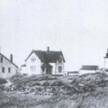
The back or east side of Cape Cod I was as dangerous to shipping in the age of sail as was Cape Hatteras. In 1798 the Cape Cod Light Station, at Highland, was established to warn ships of the Cape and to mark the route to Boston. Ten years later Cape Cod's second light station at Chatam was constructed. This station, about 23 miles south of the Cape Cod lighthouse, was a dual tower station. Each tower displayed a fixed white light, distinguishing this lighthouse from the Cape Cod light with its single white beam.

At 260 feet above sea level, the Highlands of Navesink is one of the highest points of land on the Eastern Seaboard of the United States. Overlooking the narrow peninsula of Sandy Hook and being only twenty-six miles from New York City, it was inevitable that the Highlands would become important to the commerce, navigation and defense of that city.