Seguin Light Station, Maine
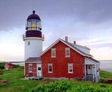
For more than two centuries, this lighthouse has been an important guide for mariners traveling along the Maine coast as well as for those entering the Kennebec River toward Bath and other ports. Even earlier, high Seguin Island, rising more than 100 feet above tihe sea, was a prominent landmark. In August 1607, the English founders of the Popham colony anchored at the island before landing on the mainland. When the explorer Samuel de Champlain sailed past the mouth of the Kennebec River in 1605, he aptly observed that the island looked like a giant tortoise.
- Read more about Seguin Light Station, Maine
- Log in to post comments
Rose Island Lighthouse, Rhode Island

Rose Island, about a mile offshore from Newport, Rhode Island, has a commanding position in Narragansett Bay's East Passage, with a clear view to the south all the way to Block Island. The local Indians knew the island as Conockonoquit, meaning "place of the long point." This name referred to a long grassy point on the island that once pastured cows, reduced by the great Portland gale of 1898 to tidal flast visibl only at low tide. The island-once more than 25 acres in size-today encompasses only about 18 acres.
- Read more about Rose Island Lighthouse, Rhode Island
- Log in to post comments
Eliphalet Grover at Boon Island, Maine, 1816-39

Boon Island Lighthouse, established in 1811 several miles off the coast of southern Maine, was one of the most isolated and desolate of New England's light stations. The first keeper was David Oliver, a carpenter who had helped build the station. Oliver soon resigned to serve as a mate on a Europe-bound ship. Thomas Hanna, a sea captain originally from Scotland and the grandfather of the Cape Elizabeth Lighthouse hero Marcus Hanna, succeeded Oliver. Hanna resigned May 1816.
Spring Point Ledge Light Station, Maine
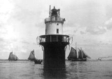
Spring Point Ledge is a dangerous obstruction on the west side of the main shipping channel from the south into Portland Harbor, just under two miles north-northwest of Portland Head. An 1896 newspaper article explained how the local fishermen found their way into the harbor while avoiding the ledge before the lighthouse was built. They would approach the tall, prominent Portland Observatory on the city's Munjoy Hill, and when it looked like Waterville Street ran right up to it, they knew they were in the right channel.
- Read more about Spring Point Ledge Light Station, Maine
- Log in to post comments
Coney Island Light Station, New York

Coney Island, now a peninsula attached to the mainland, was formerly the weseternmost of the barrier islands off New York's Long Island. The island was named for its once teeming rabbit population; coney is an old word for rabbit. A bill "to establish lights at the western end of Coney Island," known as Norton's Point (after a nineteenth-century politician who once ran a hotel at the point), was introduced in Congress in 1888. J.O. Coleman, New York City's commissioner of street cleaning, urged passage of the bill in a February 1889 letter to New York's representatives in Congress.
- Read more about Coney Island Light Station, New York
- Log in to post comments
Cape Neddick Light Station, Maine

A short distance off the eastern point of Cape Neddick in the town of York, Maine, about two miles north of the entrance to them York River and a mile south of the entrance to the Cape Neddick River, is a high rocky island-about two and a half acres in area-known as the Nubble. It's separated from the area now known as Sohier Park on the mainland by a narrow channel, about 100 feet wide, that's almost dry at low tide. The explorer Bartholomew Gosnold, who met with local Indians there in May 1602, dubbed the island Savage Rock.
- Read more about Cape Neddick Light Station, Maine
- Log in to post comments
Stratford Shoal Lighthouse, Connecticut
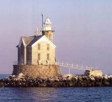
Stratford Shoal Light has often been categorized as a New York lighthouse, but according to U.S. Geological Survey maps, it's clearly on the Connecticut side of the border in Long Island Sound by about 1000 feet. Beginning around 1820, Stratford Shoal-also known as Middleground Shoal-about three-quarters of a mile in length, was marked by two spar buoys to the north and south.
- Read more about Stratford Shoal Lighthouse, Connecticut
- Log in to post comments
Highland Lighthouse: First Lighthouse on Cape Cod

When Truro, the second most northerly town on Cape Cod, was first settled as Pamet 1646, it was part of the larger area then called Nauset. Pamet's name was changed to Truro (after a Cornish town it was said to resemble) when it was incorporated as a separate town in 1709. Truro developed a whaling fleet based at Pamet River Harbor, which comprised nine sloops by the early 1800s. In its early years, mariners knew Pamet as Dangerfield because of the frequent wrecks off its shores.
Block Island North Lighthouse

Block Island has been proclaimed "one of the last great places in the Western Hemisphere" by the Nature Conservancy, and the "Bermuda of the North" by tourism bureaus. Those descriptions are apt, but the pork chop-shaped island was long cursed as a stumbling block for coastal shipping traffic. The island is 14 miles from Point Judith, Rhode Island, and the same distance from Montauk Point, New York.
- Read more about Block Island North Lighthouse
- Log in to post comments